Treasures of JapanA catalogue of Japan's designated cultural properties 2,690 works catalogued

Home › Browse › Calligraphy & Books › Kamakura period › Map of the Fields of Otogi no shō Estate in Yamato Province
Important Cultural Property

Map of the Fields of Otogi no shō Estate in Yamato Province

大和国乙木庄条里坪付図
Map of the Fields of Otogi no shō Estate in Yamato Province (大和国乙木庄条里坪付図)
PLATE IImage: Nara National Museum, via ColBase — CC BY 4.0
At a glance — Calligraphy & Book · Kamakura period, 13th century · held by Nara National Museum · designated Important Cultural Property of Japan.

Fact Sheet

Designation
Important Cultural Property (重要文化財)
Date
1201–1300
Catalogue ID
cobas-16112

Find more

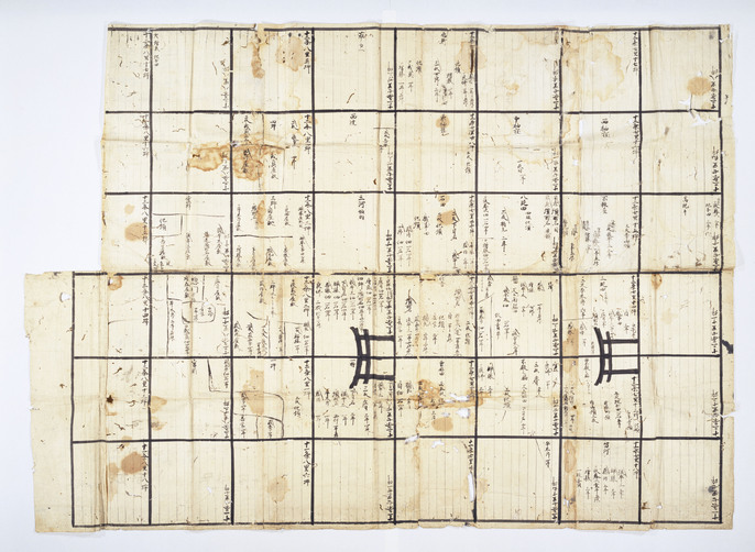
This map lays out the land estates in the environs of present-day Otogi in Tenri that belonged to Daijō-in Temple, a sub-temple of Kōfuku-ji Temple. The land has been divided into a grid of plots, and these plots are further divided into sections, many of which are cultivated by individuals whose names are written over the area for which they are responsible. The map also features the pictorial element of two Tori-i gates lined up over several plots.

— Museum description: Nara National Museum (CC BY 4.0), via ColBase / Japan Search.

Record & Sources

Cite this page: “Map of the Fields of Otogi no shō Estate in Yamato Province(大和国乙木庄条里坪付図).” Treasures of Japan, catalogue no. cobas-16112. Nara National Museum. https://treasures.yamato-kenkou.com/treasures/map-of-the-fields-of-otogi-no-sh-estate-in-yamato-province/ — entry last verified 1 November 2026.
Full record data (as published in the official catalogue record)
  • Genre: Writings
  • Material: Ink on paper
  • Cultural property designation: Important Cultural Property
  • Category: Calligraphy:Category:Maps
  • 員数: 1鋪
  • 分類: 書跡
  • 品質形状: 紙本墨書
  • 法量: 縦94.0 横129.5
  • 種別: 書跡:分類:絵図

Also at the Nara National Museum More →

More calligraphy & books of the Kamakura period More →

Advertisement