Treasures of JapanA catalogue of Japan's designated cultural properties 2,690 works catalogued

Home › Browse › Historical Materials › Muromachi period › Map of Kamo Shrine

Important Cultural Property

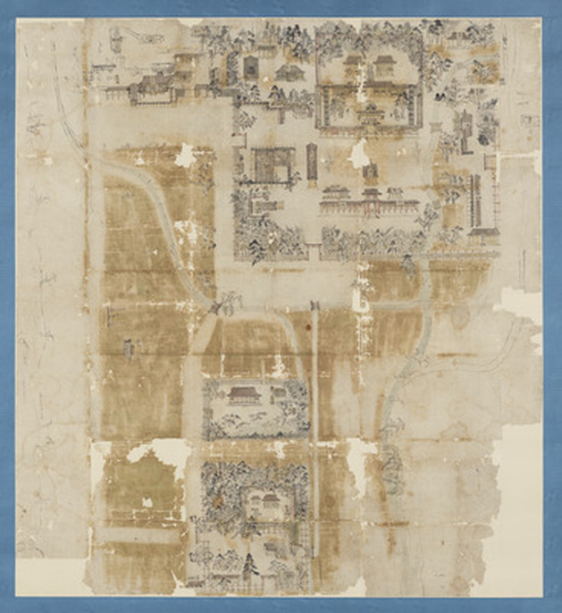
Map of Kamo Shrine

賀茂御祖神社絵図
Map of Kamo Shrine (賀茂御祖神社絵図)
PLATE IImage: Kyoto National Museum, via ColBase — CC BY 4.0
At a glance — Historical Material · Muromachi period, 15th century · held by Kyoto National Museum · designated Important Cultural Property of Japan.

Fact Sheet

Designation
Important Cultural Property (重要文化財)
Date
1401–1500
Catalogue ID
cobas-3

Find more

This fifteenth-century map shows the precincts of Kyoto’s Shimogamo Shrine, located on the east bank of the Kamo River. Some of the shrine buildings are labeled with inscriptions, making this map an invaluable source for tracing changes in the shrine complex over time.

— Museum description: Kyoto National Museum (CC BY 4.0), via ColBase / Japan Search.

Record & Sources

Cite this page: “Map of Kamo Shrine(賀茂御祖神社絵図).” Treasures of Japan, catalogue no. cobas-3. Kyoto National Museum. https://treasures.yamato-kenkou.com/treasures/map-of-kamo-shrine/ — entry last verified 1 November 2026.
Full record data (as published in the official catalogue record)
  • Cultural property designation: Important Cultural Property
  • Genre: History
  • Category: Historical materials:Maps, plans, and illustrations
  • 員数: 1幅
  • 分類: 歴史
  • 種別: 歴史資料:絵図・地図類

Also at the Kyoto National Museum More →

Important Cultural Property
Ballad by Sakamoto Ryoma (坂本龍馬関係資料 詠草三 俚謡)

Ballad by Sakamoto Ryoma

坂本龍馬関係資料 詠草三 俚謡
Historical Materials · Edo, 1801–1900Kyoto NM

More historical materials of the Muromachi period More →

Advertisement